

other dog
-
Posts
15,135 -
Joined
-
Last visited
-
Days Won
525
Content Type
Profiles
Forums
Gallery
Events
Blogs
BMT Wiki
Collections
Store
Everything posted by other dog
-
vacation is over-gotta go to Warren,Oh. tomorrow.Might be a good thing-I need a break,worked harder this week than I do at work!
-
thanks a lot
-
(expletive)!..never heard that story. maybe I should "accidently" break it and take it back. naw, that wouldn't work, that's bad luck too. well, it's her mirror.
-
Just made a trip over to the dumpster. Loaded both ways this time, no deadhead. Dropped off some trash and reloaded a nice looking mirror somebody left on the ground and brought it home. Wasn't even me this time, Jobyna wanted it-she's already got it cleaned up and setting in the bedroom. Not bad looking at all.
-
why sure
-
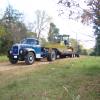
Just got back from Toga, Va. a little while ago. Been there most of the day. Pretty good time, and for a good cause. Didn't look like as good a turnout this year as there has been, "...but with this economy..." as all the politicians like to say, it wasn't bad either. Not as many vehicles in the car show, but what was there was nice. More motorcycles than i'd ever seen before, and quite a few tractors in the tractor show. As for the mixer, it's still got a little shake and shimmy, but nowhere near as bad as it was. Almost a pleasure to drive! 2 new steer tires should fix that, still got bias ply tires on the front. But it ran great. Here's some pictures of bikes, cars, babes, and barbecue. They cooked 3 hogs all night, then they took all the meat and chopped it up and put it in these aluminum pans with more bbq sauce and let it simmer on the grill until it's done. They also had barbecued chicken, sausage bistits, and hot dogs. S 10 pickup S 10 pickup engine '57 Chevy '67 Chevelle Ford row Mixer back at H.Q. BBQ on the grill Thought Rob was there... ...looked like his bike... No, she wasn't there, but I said babes, and since this is the hottest babe i've ever seen... photo by Vision386
-
Never been in a Starbucks either...probably never will.
-
I always liked the 3000 Whites too. I've heard them called them a "suicide White" but that is a neat looking cab.
-
you're right, let's get back on track. Hmmm...I dunno, this looks kinda painful. Interesting though.
-
you know what they say- "use it or lose it"
-
they even have a website- http://www.ferebee-johnson.com/index.html
-
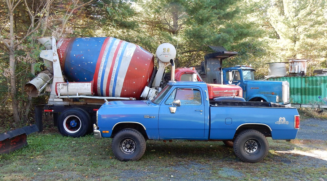
At last- I now have 8 brand new used tires and wheels on that cement mixer truck! Finally got the last 3 wheels from Litchford's Garage at 8 this morning, then it was a mad scramble to get them on the truck. First I finished painting the wheels, putting the white strip on them, then I greased the truck while the wheels were drying, then... then the truck wouldn't start. It would start and run a few seconds and cut off. I took the filter off and it wasn't half full of fuel, so I poured it out, refilled it and put it back on. Starts up, runs a few seconds, then cuts of. Took the line off from the tank to the filter and it looked dry. Tom came out of the shop, he mounted all the tires on the wheels for me, and said "there's the problem,you're leaking fuel". So I jumped down and looked and the old braided line that comes out of the tank was leaking where it makes a bend and goes up under the cab. It wasn't leaking at first because i'd been all up under it greasing it just minutes before and there was no leak. I think the hose was so old it was probably sucking together on the inside. So I took the line off and went to Lynchburg to Ferebee-Johnson to get a new fuel line. The man said "what'd this come off of?". I said "a '65 Mack". He said "looks like it's been on there since '65". I said "probably has". Came back and put it on, got it started with some ether, backed up to the shop door, and went to jacking up, taking off, putting on, and sweating my ass off. Finished about 4:30, then I washed at it some, I was dog tired...still am. This would-should-have been done Wednesday, but the delay getting the wheels put me in a bind. Got 8 good looking 11R-22.5 Bridgestones on it now though. They're about 2 inches shorter than the 11:00-20's I took off. One of them was a Sears by the way. Don't remember ever seeing a Sears truck tire before-might be a '65 model too. Was gonna drive it down the road to check them out, but there was no way I was gonna try to get in 460 that time of day, especially on Friday.
-
whew!..glad you've got a good sense of humor and didn't send a posse after me...you didn't, did you?
-
you haven't seen scary yet-
-
managed to get 5 today, painted 4 of them. I went ahead and paid for all 8 since they said they'd have the other 3 this evening. Went back twice this evening and there was no one to be seen, and no wheels either. Jimmy's already picked out some nice looking Bridgestone tires for me.
-
of all the things they could have turned over for the wrecker demonscration, why'd they have to pick a mixer?
-
Thanks David, i've got a few leads to call this morning. If I don't come up with anything today i'll do that. Raleigh's not that far from here, probably easier than having Rob import them from Chicago. Struck out on all my leads. Called Bebo back last and he said he'd have them ready by mid day today-but i've heard that one before!
-
Ain't been in a Peterbilt all week. Don't smoke any dope anyway. Tried it in the '70's, like everybody else, but I never inhaled. I'm going crazy on vacation over the wheel deal. Where've you been so long Paul?..we've missed you
-
I'm just sayin'...
-
no need to worry...trust me.
-
thought you weren't allowed to buy anything!! anyway,I might be interested if something doesn't come through by tomorrow. Waiting on a guy to call back now that might have some used ones. I'll drive it down there on the old tires if I have to. It's about a 20 mile trip each way.
-
do NOT be afraid to post all the pictures you want!..trust me.
-
I wish...man, she is smokin' hot!
-
Excellent job!..i'd have done the same thing...i'm so proud of you!
-
Looks great guys...i'm so pissed off now i'd pay twice as much for wheels if I could find them somewhere else. I'm gonna call Fleetpride in the morning and see what new ones cost. I called Litchford's (Bebo) a month or more ago and told him I wanted the wheels-no rush. He said "fine, whenever you want them,i've got plenty of them-$40 apiece." Called early Monday and he said the wheels were already off,ready to go. I had other things to do Monday anyway, so I went back yesterday and they said the wheels were not off,and they had to take the tires off of them-no good,rotten ass, recapped tires at that-"come back tomorrow- after lunch- and we'll have them ready". Went back today-after lunch-same story as yesterday. You shouldn't tell somebody you're gonna do something and then not do it...i'm just pissed off to the highest level of pissedofftivity right now. That was my main objective while i'm on vacation-Lincolnton truck show last weekend,the Toga annual benefit this coming weekend-to finally get those tires on the mixer. I was a paycheck from being broke last winter-literally-but i've been running my ass off lately and decided I was gonna do it and get the wheels and tires on it this week so I can drive it again and take it to the car show at Toga. Never missed one yet, and don't plan to miss this one. The second annual benefit was for my wife, who died of cancer in 2005. Here's some info on this year's benefit- http://www.facebook.com/event.php?eid=139497816068403


BMT Forum Logo